

Boost the efficiency of data collection by quickly creating reality models that include plots and attachments using high-accuracy drone solutions.
Generate 2D orthomosaics in real-time so teams can immediately visualize land cover and identify any changes.
Map and model large areas quickly with drones to produce data for accurate 2D and 3D models.

Field work requires many teams putting in long manhours, extending project timelines and incurring higher costs.
It is difficult to visualize the property or the lot in question using traditional survey outcomes like vector maps alone.
Generate 1:500 scale maps without using GCPs while meeting centimeter-level accuracy requirements.
Improve the efficiency of data collection and processing up to 10 times, acquiring deliverables quickly and shortening project lifecycles.
Gain industry-standard outputs like DOM, DSM, 3D reality models and more.
Small teams can cover large areas quickly by operating multiple drones with a single remote controller.
Versatile Platform
Use with the integrated P1 and L1 payloads and the DJI Terra software to efficienctly capture high-accuracy image and Lidar data for a variety of surveying scenarios.

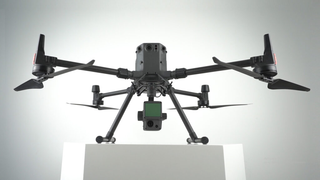
DJI L1

DJI P1

DJI TERRA

Rapid Mapping Solution
An intuitive surveying solution that captures centimeter-level accurate data and creates georeferenced 2D maps and 3D models.
DJI TERRA


Satellite data is expensive and cannot be accessed on demand, while the resolution and data accuracy are subpar.
Field work is slow and inefficient using total stations and handheld RTK devices. Collecting usable data is difficult in remote areas or locations with obstructions.
Visualize results quickly using real-time 2D orthomosaics or create accurate, high-resolution maps in post-processing.
Significantly reduce costs by using affordable drone and software solutions that automate data collection and processing.
Keep digital records that can be easily used for regular land cover comparisons, so teams can monitor changes dynamically.
Versatile Platform
The P1 payload is an integrated solution for efficiently capturing orthomosaic data without GCPs.
DJI P1
DJI TERRA

Rapid Mapping Solution
An intuitive surveying solution that captures centimeter-level accurate data and create georeferenced 2D maps and 3D models.
DJI TERRA

Vegetation Management Solution
A multispectral imaging solution that captures centimeter-level accurate data and creates vegetation index maps for vegetation management.
DJI TERRA


Large amounts of field work is required, involving multiple teams and stakeholders. Project costs are high with lengthy timelines.
Projects are often delayed due to inefficient data collection methods.
Contour data is not part of the standard deliverable, resulting in difficulties in data visualization.
Generate 1:500 scale maps without using GCPs while meeting centimeter-level accuracy requirements.
Improve the efficiency of data collection and processing up to 10 times, acquiring deliverables quickly and shortening project lifecycles.
Gain industry-standard outputs like DOM, DSM, 3D reality models and more.
Small teams can cover large areas quickly by operating multiple drones with a single remote controller.
Versatile Platform
Use with the integrated P1 and L1 payloads and the DJI Terra software to efficienctly capture high-accuracy image and Lidar data for a variety of surveying scenarios.
DJI L1
DJI P1
DJI TERRA
Rapid Mapping Solution
An intuitive surveying solution that captures centimeter-level accurate data and creates georeferenced 2D maps and 3D models.
DJI TERRA


We will keep you up to date with more stories about drones and other relevant updates. If you are interested in purchasing any of our solutions, you can contact us for further information.
